


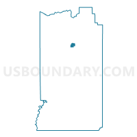
Naples Voting District, Uintah County, Utah
About
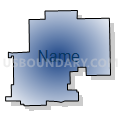
Outline

Summary
| Unique Area Identifier | 680062 |
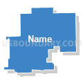
| Name | Naples Voting District |
| County | Uintah County |
| State | Utah |
| Area (square miles) | 6.64 |
| Land Area (square miles) | 6.64 |
| Water Area (square miles) | 0.00 |
| % of Land Area | 100.00 |
| % of Water Area | 0.00 |
| Latitude of the Internal Point | 40.43164980 |
| Longtitude of the Internal Point | -109.49127920 |
Maps

Graphs
Select a template below for downloading or customizing gragh for Naples Voting District, Uintah County, Utah


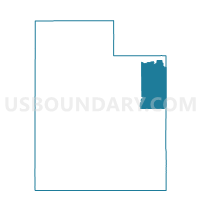
Neighbors
Neighoring Voting District (by Name) Neighboring Voting District on the Map
- Ashley East Voting District, Uintah County, UT
- Davis North A Voting District, Uintah County, UT
- Davis North B Voting District, Uintah County, UT
- Davis West Voting District, Uintah County, UT
- Glines East Voting District, Uintah County, UT
- Vernal 13 Voting District, Uintah County, UT
Top 10 Neighboring County Subdivision (by Population) Neighboring County Subdivision on the Map
Top 10 Neighboring Place (by Population) Neighboring Place on the Map
Top 10 Neighboring Unified School District (by Population) Neighboring Unified School District on the Map
Top 10 Neighboring State Legislative District Lower Chamber (by Population) Neighboring State Legislative District Lower Chamber on the Map
Top 10 Neighboring State Legislative District Upper Chamber (by Population) Neighboring State Legislative District Upper Chamber on the Map
Top 10 Neighboring 111th Congressional District (by Population) Neighboring 111th Congressional District on the Map
Top 10 Neighboring Census Tract (by Population) Neighboring Census Tract on the Map
- Census Tract 9682, Uintah County, UT (7,450)
- Census Tract 9684.02, Uintah County, UT (5,779)
- Census Tract 9684.01, Uintah County, UT (3,732)